Purposely keeping this short and sweet.
Paiyun Lodge 'at the very earliest' will reopen late October 2012. We shall see...
Baiyang Trail (original route) is open again. We have seen.
Shakadang Trail will be closed for some time due to damage caused by Typhoon Soala. Don't want to see.
Most other stuff as normal. Take care!
Monday, August 6, 2012
Thursday, February 23, 2012
Paiyun continued...
Paiyun continued...
 It
may surprise my some of my friends (if they were really listening to me
in the last couple years), but I do have a life beyond figuring out
options for climbing Yushan.
It
may surprise my some of my friends (if they were really listening to me
in the last couple years), but I do have a life beyond figuring out
options for climbing Yushan.
The main cabin on Yushan - Paiyun Lodge - made the English news today. I have reproduced the article from the Taipei Times below that makes public some of the rumors I have been hearing. A couple minor errors, and dodgy interpretations, but gives you a flavor of the issues involved
My conclusions: The conventional approach to Yushan (staying in Paiyun) may not be available as hoped for this spring/summer. This legal argument could drag on some time - I hope I am wrong.
In the meantime if you are fit and have good mountain hiking experience, and really want to get to the highest point in Taiwan, then the only half-sensible option is the tough single-day ascent. If you just want to do fantastic hiking in great mountains, then consider other trails such as Snow Mountain, the Hehuan area, and in greater Taroko. Taiwan has much, much more than Yushan (Jade Mountain). Richard HikeTaiwan@gmail.com
Yushan National Park (YSNP) have announced (well not really announced - more sheepishly let slip out that is) that:
Once Paiyun reopens, foreigners will pay three times what Taiwanese will for the use of the lodge. Their reasoning is that ‘this is what happens overseas’, and ‘is to cover the cost of bilingual services’. I ask - does this make it right, or a good overall idea? What bilingual services? Their website, trail signs, hiking maps, signs at Paiyun, and other advice is the worst of the other equivalent Taiwan organizations - Taroko NP, Shei-pa NP, Forestry Bureau etc.
Another issue: once Paiyun reopens, foreigners will not be allowed (regardless of being able to prove extensive experience on serious Taiwanese or foreign mountains) to apply for single day ascents. Idiotic! Unsafe!
Quick FAQ notes:
Complaints raised over Yushan lodge
Yushan National Park Administration may have violated the Government Procurement Act (政府採購法) and the Construction Industry Act (營造業法) in the reconstruction of the Pai Yun Lodge (排雲山莊), a source said.
The lodge is a rest building for hikers, located 3,400m above sea level. It can accommodate 82 hikers in the main building and 20 in its camping area. Due to the heavy traffic on Yushan hiking trails, the park administration decided to refurbish the lodge and add a second floor in 2010. However, environmental protection groups opposed the plan on grounds that it might cause an ecological disaster.
To allay those concerns, the administration spent NT$1.3 million (US$43,946) in 2009 commissioning outside sources to evaluate the lodge project, and in 2010 spent another NT$900,000 on environmental and ecological monitoring.
Construction began in October 2010, but was soon met with protests.
A reader who tipped off the Liberty Times (the Taipei Times’ sister newspaper) on the alleged violations said the park administration had torn everything down except a few walls, and was actually rebuilding the whole building under the guise of refurbishing.
The administration’s methods to sidestep environmental criticism were in themselves very controversial, the reader said.
The reader said that in an effort to evade inspection by the Public Construction Commission and to be able to apply for green architecture labels, the park administration said it was only spending NT$40 million, but the estimates deliberately omitted the expense of airlifting materials by helicopter, which would have brought expenditures close to NT$100 million.
The park administration may have violated the law, the reader said, adding that it was illogical that the designers weren’t looking into the matter because there was such a serious breach of design.
Deputy park administration Director Wu Hsiang-chien (吳祥堅) said that while it was true that there were some additional fees in the construction process, any such fees would be handled through contracts.
The original budget for the construction stood at NT$45 million, and the winning construction bid came in at NT$38 million, Wu said. However, due to multiple design changes during construction process, the budget had been increased to NT$44 million.
The differences in the design conception of the construction and the design companies may cause the cost to increase to more NT$50 million, but no costs had been omitted from the budget quotes, Wu said.
The project is currently 93 percent complete, the park administration said, adding that it had asked the construction company to expedite work and finish quickly to avoid inconveniencing domestic and foreign hikers.
‧ The Yushan National Park Administration spent NT$1.3 million (US$43,946) in 2009 on outside sources to evaluate the lodge project.
‧ It spent NT$900,000 on environmental and ecological monitoring.
‧ The original budget for the project was NT$45 million, but the winning bid was NT$38 million.
‧ Multiple design changes have boosted the budget to NT$44 million.
‧ A complaint says the true cost may reach NT100 million.
 It
may surprise my some of my friends (if they were really listening to me
in the last couple years), but I do have a life beyond figuring out
options for climbing Yushan.
It
may surprise my some of my friends (if they were really listening to me
in the last couple years), but I do have a life beyond figuring out
options for climbing Yushan.The main cabin on Yushan - Paiyun Lodge - made the English news today. I have reproduced the article from the Taipei Times below that makes public some of the rumors I have been hearing. A couple minor errors, and dodgy interpretations, but gives you a flavor of the issues involved
My conclusions: The conventional approach to Yushan (staying in Paiyun) may not be available as hoped for this spring/summer. This legal argument could drag on some time - I hope I am wrong.
In the meantime if you are fit and have good mountain hiking experience, and really want to get to the highest point in Taiwan, then the only half-sensible option is the tough single-day ascent. If you just want to do fantastic hiking in great mountains, then consider other trails such as Snow Mountain, the Hehuan area, and in greater Taroko. Taiwan has much, much more than Yushan (Jade Mountain). Richard HikeTaiwan@gmail.com
--------------------------------------------------------------------
A couple other bits of (early March) info/personal observations.Yushan National Park (YSNP) have announced (well not really announced - more sheepishly let slip out that is) that:
Once Paiyun reopens, foreigners will pay three times what Taiwanese will for the use of the lodge. Their reasoning is that ‘this is what happens overseas’, and ‘is to cover the cost of bilingual services’. I ask - does this make it right, or a good overall idea? What bilingual services? Their website, trail signs, hiking maps, signs at Paiyun, and other advice is the worst of the other equivalent Taiwan organizations - Taroko NP, Shei-pa NP, Forestry Bureau etc.
Another issue: once Paiyun reopens, foreigners will not be allowed (regardless of being able to prove extensive experience on serious Taiwanese or foreign mountains) to apply for single day ascents. Idiotic! Unsafe!
Quick FAQ notes:
- No camping at Paiyun.
- The main peaks are not open yet (early March) but possibly will be by April.
- If wanting great hiking on great mountains - and not ‘needing’ to do Yushan - consider some of Taiwan’s other mountains.
-----------------------------------------------------------------
Complaints raised over Yushan lodge
BROKEN LAWS? One complainant said the park was actually rebuilding the entire lodge, not refurbishing it, and that the true cost was being kept a secret
Yushan National Park Administration may have violated the Government Procurement Act (政府採購法) and the Construction Industry Act (營造業法) in the reconstruction of the Pai Yun Lodge (排雲山莊), a source said.
The lodge is a rest building for hikers, located 3,400m above sea level. It can accommodate 82 hikers in the main building and 20 in its camping area. Due to the heavy traffic on Yushan hiking trails, the park administration decided to refurbish the lodge and add a second floor in 2010. However, environmental protection groups opposed the plan on grounds that it might cause an ecological disaster.
To allay those concerns, the administration spent NT$1.3 million (US$43,946) in 2009 commissioning outside sources to evaluate the lodge project, and in 2010 spent another NT$900,000 on environmental and ecological monitoring.
Construction began in October 2010, but was soon met with protests.
A reader who tipped off the Liberty Times (the Taipei Times’ sister newspaper) on the alleged violations said the park administration had torn everything down except a few walls, and was actually rebuilding the whole building under the guise of refurbishing.
The administration’s methods to sidestep environmental criticism were in themselves very controversial, the reader said.
The reader said that in an effort to evade inspection by the Public Construction Commission and to be able to apply for green architecture labels, the park administration said it was only spending NT$40 million, but the estimates deliberately omitted the expense of airlifting materials by helicopter, which would have brought expenditures close to NT$100 million.
The park administration may have violated the law, the reader said, adding that it was illogical that the designers weren’t looking into the matter because there was such a serious breach of design.
Deputy park administration Director Wu Hsiang-chien (吳祥堅) said that while it was true that there were some additional fees in the construction process, any such fees would be handled through contracts.
The original budget for the construction stood at NT$45 million, and the winning construction bid came in at NT$38 million, Wu said. However, due to multiple design changes during construction process, the budget had been increased to NT$44 million.
The differences in the design conception of the construction and the design companies may cause the cost to increase to more NT$50 million, but no costs had been omitted from the budget quotes, Wu said.
The project is currently 93 percent complete, the park administration said, adding that it had asked the construction company to expedite work and finish quickly to avoid inconveniencing domestic and foreign hikers.
‧ The Yushan National Park Administration spent NT$1.3 million (US$43,946) in 2009 on outside sources to evaluate the lodge project.
‧ It spent NT$900,000 on environmental and ecological monitoring.
‧ The original budget for the project was NT$45 million, but the winning bid was NT$38 million.
‧ Multiple design changes have boosted the budget to NT$44 million.
‧ A complaint says the true cost may reach NT100 million.
Friday, December 30, 2011
2011 Round-up
Hope you all enjoying the holiday season - and that you will have time in 2012 to explore Taiwan more.
 An end-of-year round-up:
Firstly, most trails/roads/cabins in most places open and in proper working order.
As usual, Yushan Main Peak Trail (from Tatajia) will close for the month of February for all hikers. Snow and ice on the trail will probably mean this being extended well into March.
The renovation of Paiyun Lodge (the main cabin on Yushan) is ongoing. Officially it is to open “after Chinese New Year”, I predict it will the summer at the earliest. We can still arrange single-day ascents (only for the fit and experienced) after the mountain reopens in March/April.
A much needed bus service between Sun Moon Lake and Alishan (via Tatajia) has been launched. Buses leave at 07:00 and 09:00. Single trip ticket: NT$307, return: NT614. More details later.
Repairs to bridges on the Walami Trail have been completed.
We’ve recently scouted out areas in the south damaged by Typhoon Morakot in 2009:
The Southern Cross-island Highway (#20, the ‘nan-heng’) remains closed to visitors between Meishan on in the west and Xiangyang on the east. There has been lots of work done to make the road passable, we hope it may open to some traffic in 2012.
The road to Tengjhih is passable but in rough shape. The Forest Recreation Area is scheduled to reopen in August.
Shanping will be closed to all visitors for at least another year or two.
Maolin and Wutai are open to visitors. Roads are generally in OK shape, lots of reconstruction work being done to roads and trails.
The wonderfully-located Tienchr Cabin reconstruction - on the Neng-gao (Cilai South) Trail is very close to completion. Should be open for use in the spring.
The highway running through Taroko Gorge is usually open. In the next few months expect delays occasionally at the east end of the Swallow’s Grotto (where there was a large landslide November 2011) and just west of Tianxiang.
Birders can look forward to the 2012 Dasyueshan (aka Anmashan) Bird Race on April 13 and 14th. As well as being one of the best places to bird in Taiwan, foreign teams qualify for free accommodation. Contact the bird society - or me for further advice.
Two useful and practical apps for traveling around Taiwan have been launched. Here and Taiwan Adventures.
Steve Crook’s handy Does and Don’ts in Taiwan is now available in Kindle format.
Wednesday, October 5, 2011
Second Asian Bird Fair, Tainan
The Second Asian Bird Fair, to be held in Tainan, is only a few days away (October 15-17). I went (on scooter) in search of info on what will be going on.
This event is (rightfully) aimed mostly at Taiwanese visitors, thus the 'bilingual' official website here follows the Taiwanese highly-animated style. In other words not very...best not to say.
The related Asian Bird Fair’s group website is here.
Saturday & Sunday
The bird race at Tataka (trailhead for Yushan) will be on November 12-13th. See the ROC (Taiwan) Wild Bird Society for registration.
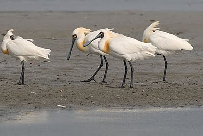
As of the start of October, there have been 11 Black-faced Spoonbills spotted in the Cigu area. If wanting a day-trip out there email me at HikeTaiwan@gmail.com
This event is (rightfully) aimed mostly at Taiwanese visitors, thus the 'bilingual' official website here follows the Taiwanese highly-animated style. In other words not very...best not to say.
The related Asian Bird Fair’s group website is here.
Saturday & Sunday
- Various activities for adults and children at the recreational docks in Anping harbor 9am to 5pm.
- Speeches, preformances, and discussion groups all day at the nearby stage and Jincheng Activities Center. Many of these will be by foreign bird group representatives - in English.
- Free shuttle buses morning and afternoon from the Wuchi side of the bridge to birdwatching sites. Route A: Sicao ‘inland sea’. Route B: Sicao mangroves ‘green tunnel’. Route C: Cigu (Qigu). First registered gets the limited spaces.
On Monday there will be other activities for invited foreign guests.
Pester me for more details. Hope to see you there.
_______________________________
The bird race at Tataka (trailhead for Yushan) will be on November 12-13th. See the ROC (Taiwan) Wild Bird Society for registration.
As of the start of October, there have been 11 Black-faced Spoonbills spotted in the Cigu area. If wanting a day-trip out there email me at HikeTaiwan@gmail.com
Tuesday, October 4, 2011
Nanhu Mountain
Nanhu Dashan (南湖大山)
If you ask 10 experienced Taiwanese high-mountain hikers which mountain is the most beautiful, 9 are likely to say ‘Nanhu’.

Taiwan’s fifth highest (3,742 meters) and the highest in the North-East. If you have climbed any of the main peaks in Shei-pa (Snow) National Park you may have watched the sun rise from behind Nanhu and its formidable neighbor, Jhongyangjian Mountain.
The trailhead is 3 hours from Taipei City in southern Yilan County, quite close to Wuling Farm - the trailhead for Snow Mountain. The first day’s trail passes through lush mixed temperate and pine forest. On later days there are expansive views from alpine meadows of dwarf bamboo, juniper and rhododendron. At the higher sections the paths traverse craggy cliffs next to enormous landslides, ending in the glacial cirques these mountains are famous for.
More photos here.
Nanhu is only suitable for the more experienced and well-prepared hiker prepared to invest between 4 and 8 days (doing a loop including Jhongyangjian). If time-limited or if there is a a lot of snow present, consider making Nanhu North Peak your target - thus avoiding the trickier fixed-rope sections before the final peaks. Less experienced hikers should consider other peaks elsewhere such as Snow Mountain, Hehuan, Cilai South etc.

I can assist in arranging logistics for this area (serious hikers only): permits, cabin booking, and booking the direct shuttle from Taipei (getting off right at the trailhead).
Monday, October 3, 2011
Paiyun Lodge - not ready yet...
Paiyun
Lodge (排雲山莊) is the only significant accommodation along the trail up
Yushan (Jade Mountain) from Tataka (Tatajia). An old structure, it
worked well when there were few hikers climbing Yushan. In recent years
its basic facilities and modest capacity were deemed insufficient for
modern climbers.
From September 2010 it has been closed and undergoing reconstruction. Real progress has been made, but many factors mean it is slow. Multiple deadlines for completion have passed. My latest prediction for it operating normally is sometime between spring and fall 2012. Please note, this is not the official line, but is based on personal observations and conversations with many individuals.
 As it was late September 2011. More images here
Prior to Paiyun being completed and opening there are essentially 2 options for those wishing to summit Yushan’s main peak. Single-day ascent, and camping at Yuan-fong. Both are tough and only suitable for the hiking-fit and experienced.
There are one or two irresponsible individuals that will boast that that these options are ‘easy’ or ‘anyone can do it’. I (as someone that regularly guides hikers to the top) want to make it clear that this is nonsense for most people. Yes, some some very fit people can run up and down it in a day without a problem, for most it is extremely exhausting and potentially dangerous.
Yushan Main Peak (via Tataka/Tatajia) will, as usual, probably be closed for the month or two around Chinese New Year. Not announced yet (wish they would plan ahead...never do), but probably January, February, maybe March. Even if open around then, there may be extra restrictions or requirements for crampons, helmets, ice-axes etc.
The longer routes into remoter parts of the National Park are opening up after the damage caused in 2009’s Typhoon Morakot. Mapo Cross-Island, the Southern Second Section, and Hsin Kang (Xinkang) Routes are now open - special case applications needed. Batongguan Cross-island is still closed. The Walami Trail should reopen within the month. I hear (haven’t personally been there recently) conflicting reports about the condition of the trail near Guanggao - some say it os OK, some say it is lethal.
Look further north in Taiwan for better trails at the moment.
From September 2010 it has been closed and undergoing reconstruction. Real progress has been made, but many factors mean it is slow. Multiple deadlines for completion have passed. My latest prediction for it operating normally is sometime between spring and fall 2012. Please note, this is not the official line, but is based on personal observations and conversations with many individuals.

Prior to Paiyun being completed and opening there are essentially 2 options for those wishing to summit Yushan’s main peak. Single-day ascent, and camping at Yuan-fong. Both are tough and only suitable for the hiking-fit and experienced.
There are one or two irresponsible individuals that will boast that that these options are ‘easy’ or ‘anyone can do it’. I (as someone that regularly guides hikers to the top) want to make it clear that this is nonsense for most people. Yes, some some very fit people can run up and down it in a day without a problem, for most it is extremely exhausting and potentially dangerous.
Yushan Main Peak (via Tataka/Tatajia) will, as usual, probably be closed for the month or two around Chinese New Year. Not announced yet (wish they would plan ahead...never do), but probably January, February, maybe March. Even if open around then, there may be extra restrictions or requirements for crampons, helmets, ice-axes etc.
The longer routes into remoter parts of the National Park are opening up after the damage caused in 2009’s Typhoon Morakot. Mapo Cross-Island, the Southern Second Section, and Hsin Kang (Xinkang) Routes are now open - special case applications needed. Batongguan Cross-island is still closed. The Walami Trail should reopen within the month. I hear (haven’t personally been there recently) conflicting reports about the condition of the trail near Guanggao - some say it os OK, some say it is lethal.
Look further north in Taiwan for better trails at the moment.
Subscribe to:
Posts (Atom)